35 injured in Xinjiang quake
 0 Comment(s)
 Print
Print E-mail China.org.cn, July 1, 2012
Thirty-five people were injured, and over 64,500 people have been affected after a 6.6-magnitude quake that jolted northwest China's Xinjiang Uygur Autonomous Region early Saturday morning, Xinhua reported.
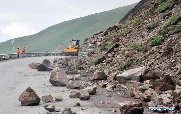
| Photo taken on June 30, 2012 shows the site of landslide caused by a quake on State Highway 218 in Hejing County, northwest China's Xinjiang Uygur Autonomous Region. An earthquake measuring 6.6 on the Richter scale jolted Xinjiang at 5:07 a.m. Saturday (2107 GMT Friday), according to the China Earthquake Networks Center. The epicenter is determined at 43.4 degrees north latitude and 84.8 degrees east longitude. [Xinhua] |
According to the preliminary investigation, quakes have killed over 2,000 heads of livestock, and damaged over 30,000 houses as of Saturday evening.
Railway authorities also stopped 32 passenger and freight trains which were running on the quake-affected regions.
The quake also triggered landslides and caused cave-ins on several national and regional highways in Xinjiang, bringing traffic to a halt. A landslide on National Highway 217 has trapped 120 people.
The regional government arranged the quake relief work and required local governments to ensure the quake victims with the safety, shelters and food supply.
Local governments have started the emergency relief preparations, allotted relief goods and relocated quake-affected people.
China Earthquake Networks Center (CENC) has launched a level-three emergency response following the quake.
The Ministy of Civil Affairs has dispatched relief goods, which include tents and quilts to quake-hit areas.
Losses and damage resulting from the quake are still being assessed and relief efforts are under way, the ministry said.
Experts said the quake-hit region, located about 3,500 meters above sea level, has been geologically active throughout history. Two earthquakes measuring higher than 7 on the Richter scale have jolted the region since 1900.


